


GPS Locations

Perihal GPS Locations
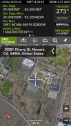
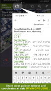
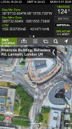
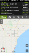
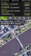
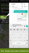
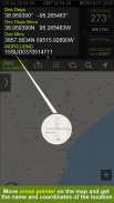
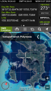
GPS Locations shows your current location, date & time to the second along with a scrollable map. You can copy your coordinates & locate anything you can find on the map with accurate crosshairs.
Have a telescope that needs your coordinates & the current time? Need to know the coordinates for your hunting stand? Going on a trek and need to find your lat/long? Want to scroll around the world and see where your favorite landmarks are? GPS Locations is what you need.
After launch, the map automatically centers on your location. Elevation is shown feet & meters. Your phone's time is shown in Greenwich Mean Time (aka Zulu time). To recenter the map on your location, just hit the crosshairs button.
*Coordinates of the map's center are shown in next formats:
- Dec Degs (DD.dddddd˚)
- Dec Degs Micro (DD.dddddd "N, S, E, W")
- Dec Mins (DDMM.mmmm)
- Deg Min Secs (DD°MM'SS.sss")
- Dec Mins Secs (DDMMSS.sss")
- UTM (Universal Transverse Mercator)
- MGRS (Military Grid Reference System)
Lokasi GPS menunjukkan lokasi semasa anda, tarikh & masa ke tempat kedua bersama peta bergulir. Anda boleh menyalin koordinat anda & cari apa-apa yang anda dapati di peta dengan penanda tepat.
Mempunyai teleskop yang memerlukan koordinat & masa semasa? Perlu tahu koordinat untuk berdiri memburu anda? Pergi ke trek dan perlu mencari lat / panjang anda? Mahu tatal di seluruh dunia dan lihat tempat mercu tanda kegemaran anda? Lokasi GPS adalah yang anda perlukan.
Selepas pelancaran, peta secara automatik berpusat pada lokasi anda. Ketinggian ditunjukkan kaki & meter. Masa telefon anda ditunjukkan dalam Greenwich Mean Time (waktu aka Zulu). Untuk mengimbas semula peta di lokasi anda, tekan butang silang.
* Koordinat pusat peta ditunjukkan dalam format seterusnya:
- Dec Degs (DD.dddddd˚)
- Dec Degs Micro (DD.dddddd "N, S, E, W")
- Dec Mins (DDMM.mmmm)
- Deg Min Secs (DD ° MM'SS.sss ")
- Dec Mins Secs (DDMMSS.sss ")
- UTM (Universal Mercverse Mercator)
- MGRS (Sistem Rujukan Grid Tentera)

GPS Locations - Maklumat APK
Versi APK: 3.7.2Pakej: com.narkira.gpslocationVersi Terkini GPS Locations
Versi lain


Aplikasi dalam kategori sama

Anda juga mungkin suka...


